


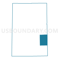
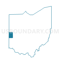
PRECINCT FRANKLIN TOWNSHIP, Darke County, Ohio
About
Outline

Summary
| Unique Area Identifier | 645301 |
| Name | PRECINCT FRANKLIN TOWNSHIP |
| County | Darke County |
| State | Ohio |
| Area (square miles) | 25.21 |
| Land Area (square miles) | 25.21 |
| Water Area (square miles) | 0.01 |
| % of Land Area | 99.97 |
| % of Water Area | 0.03 |
| Latitude of the Internal Point | 40.04358910 |
| Longtitude of the Internal Point | -84.46943860 |
Maps

Graphs
Select a template below for downloading or customizing gragh for PRECINCT FRANKLIN TOWNSHIP, Darke County, Ohio


Neighbors
Neighoring Voting District (by Name) Neighboring Voting District on the Map
- PRECINCT ADAMS EAST & BRADFORD, Darke County, OH
- PRECINCT ADAMS WEST & GETTYSBURG, Darke County, OH
- PRECINCT MONROE TWP & PITSBURG VILLAGE, Darke County, OH
- PRECINCT NEWBERRY WEST, Miami County, OH
- PRECINCT NEWTON WEST, Miami County, OH
- PRECINCT TWIN TWP GORDON & ITHACA, Darke County, OH
- PRECINCT VAN BUREN TOWNSHIP, Darke County, OH
Top 10 Neighboring County Subdivision (by Population) Neighboring County Subdivision on the Map
- Newberry township, Miami County, OH (6,449)
- Twin township, Darke County, OH (4,060)
- Adams township, Darke County, OH (3,441)
- Newton township, Miami County, OH (3,399)
- Monroe township, Darke County, OH (1,735)
- Van Buren township, Darke County, OH (1,469)
- Franklin township, Darke County, OH (1,241)
Top 10 Neighboring Unified School District (by Population) Neighboring Unified School District on the Map
- Greenville City School District, OH (22,536)
- Arcanum-Butler Local School District, OH (5,856)
- Franklin Monroe Local School District, OH (3,452)
- Bradford Exempted Village School District, OH (3,261)
- Newton Local School District, OH (3,247)
Top 10 Neighboring State Legislative District Lower Chamber (by Population) Neighboring State Legislative District Lower Chamber on the Map
Top 10 Neighboring State Legislative District Upper Chamber (by Population) Neighboring State Legislative District Upper Chamber on the Map
Top 10 Neighboring 111th Congressional District (by Population) Neighboring 111th Congressional District on the Map
Top 10 Neighboring Census Tract (by Population) Neighboring Census Tract on the Map
- Census Tract 5701.02, Darke County, OH (5,795)
- Census Tract 3201, Miami County, OH (3,594)
- Census Tract 5401, Darke County, OH (3,441)
- Census Tract 3301, Miami County, OH (3,399)
- Census Tract 5701.01, Darke County, OH (2,922)